Freedom Energy Newsletter | December 2024
What to Expect from a Neutral Winter in 2024–2025
We are officially in meteorological winter as of December 1, and it’s starting to look like it across the United States. La Niña still has not materialized in the equatorial Pacific, with the latest Climate Prediction Center (CPC) report showing continued neutral conditions. The latest ONI (Oceanic Niño Index) from September, October, and November has been observed at -0.2°C, which is the same as the previous three-month observations of August, September, and October. We may achieve a borderline weak La Niña briefly this winter, but it’s more likely we remain neutral through the winter and into next summer.
We’re familiar with El Niño and La Niña winters, so what does a neutral winter bring? It’s somewhat of a blend of the two, and since there’s no overarching global influence from the ENSO (El Niño Southern Oscillation) cycle, more regional influences can have an effect throughout the winter. The last neutral winter was 2013-2014.
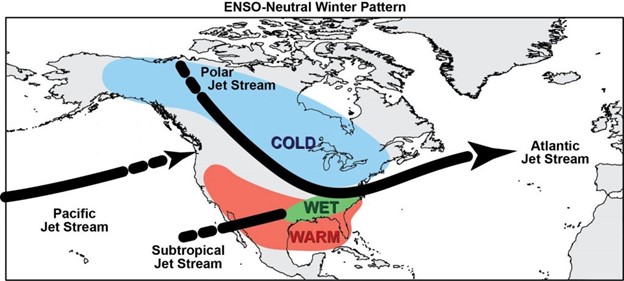
Image Courtesy of the National Weather Service
When you have an overarching global pattern in a moderate or strong phase, it’s rare to see patterns that don’t align with them. However, in a neutral phase, more variable or transient patterns develop – where the pattern is akin to rolling hills, rather than always up or downhill. It’s unlikely to experience major extremes or volatility similar to last winter, though we’re not getting overly comfortable in a pattern either. Temperatures shouldn’t stray too far from average – cold outbreaks will be somewhat evened out by warmer periods, apart from the far southeast where neutral patterns favor warm conditions and the western Great Lakes/Northern Plains where the cold settles a bit more.
Since we’re leaning toward a weak La Niña phase (though not quite there), the western storm track likely brings more precipitation toward the Pacific Northwest, rather than the California coast, through most of the winter. However, since ENSO is inherently neutral to start, we may see beneficial rain and snow come through from time to time, especially toward the latter part of the winter when we’ll likely see ONI observations go back toward zero or even slightly positive. This could also ignite a stormier end to winter, especially along the eastern seaboard, particularly if we hedge close to a weak El Niño. Weak El Niño phases tend to favor the infamous “Pineapple Express” streams of moisture, which can ultimately help produce strong nor’easters. While a weak El Niño is not poised to come to fruition this winter, it’s certainly on the table for next winter.
Meet the Writer

Mallory Brooke
Certified Consulting Meteorologist
Nor’easter Weather Consulting
Mallory Brooke, Freedom Energy’s Meteorologist and Certified Consulting Meteorologist from Nor’easter Weather Consulting, contributes her expertise in forecasting winter trends.
Mallory Brooke, a Certified Consulting Meteorologist and Penn State graduate, began her career in Virginia before moving to Maine in 2011, where she specialized in ski area forecasting. She founded Nor’easter Weather Consulting in 2017 and has been the Official Meteorologist for the Audi FIS World Cup at Killington since 2016. Alongside her meteorological career, Mallory contributes to outdoor recreation media in Portland, ME, and holds an MBA with a concentration in Business Analytics from the University of Maine.





Connect With Us