January 12, 2024
The Polar Vortex Effect: Influence on Energy Market
According to Howard Plante, as the colder Polar Vortex causes greater demand for natural gas heating requirements and electricity use, it is expected that the futures prices will rise for both commodities, as well as spot market prices. New England spot market power prices will rise based on the price of natural gas in the spot market.
If the polar vortex does not fully reach into New England and the temperatures are less severe, the pricing effect in the spot market for electricity should not be as significantly impacted, but still elevated. Although natural gas prices will be higher, and New England relies heavily on natural gas for electricity generation, demand for both electricity and natural gas will be less than they would otherwise be with the full Polar Vortex impact.
Futures prices are affected by many factors; economy, conditions in Europe, long term weather forecasts, supply and demand constraints, etc. All else being equal, the Polar Vortex effect on futures prices would be expected to be short-lived. The impact to prices in the spot market would likely drop based on the return of normal or average temperatures.
The Polar Vortex, when its influence extends from the Arctic across the United States, can bring cold temperatures and severe winter weather to the New England region, significantly affecting energy demand and local weather patterns.
What is the Polar Vortex
 The Polar Vortex has had more airtime over the last several years, and the term is latched onto when temperatures plunge well below normal in the winter months. This cold intrusion is linked to stratospheric warming events, which we touched on briefly in Freedom Energy’s Analyzing the Winter Trends Newsletter article in December.
Let’s start with stratospheric warming. The stratosphere is roughly 10-50km into the atmosphere, the next sector of the atmosphere above the troposphere, which is where weather lies, as do we. The image to the left, courtesy of UCAR[i], shows four sections of the atmosphere – missing the Exosphere, which is above the Thermosphere (think infinity, and beyond!).
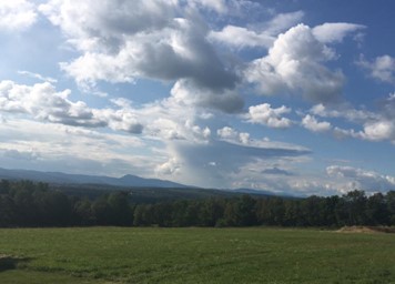
The troposphere and stratosphere are separated by the tropopause. This is the point at which temperatures warm with height, which is the opposite of what we typically see in the troposphere (unless we have inversions). While you cannot see the tropopause, you can occasionally get a visual from thunderstorm anvils in the summer. You will notice that at some point the cumulonimbus cloud no longer grows in height, and the clouds spread horizontally – that is the tropopause (for example, in the photo to the right from a Farmington, ME thunderstorm).
 Stratospheric warming is defined as a mass warming event in the stratosphere, increasing temperatures by some 50 degrees Celsius in a matter of days. Given that it is incredibly high up in the atmosphere, we do not feel that warming at the surface, but it has been linked to the opposite. We will generally see intense cooling in southern Canada and the United States about 30-60 days later.
How the Polar Vortex Alters Weather Patterns
We have to go back to the polar vortex: “Vortex” refers to the counterclockwise winds (westerly) around the low pressure, and “Polar,” because we are up in the poles. This permanent low pressure resides at our poles year-round, and this tight ring of arctic westerlies circles the North Pole. There is a teleconnection, called the Arctic Oscillation (AO, for short) that is essentially a measure of the polar vortex’s strength.
The polar vortex does not appear and reappear – you hear about it (and feel it) when it weakens, and the AO goes into a negative phase. When the ring of westerlies weakens, the vortex breaks down, and can even sometimes allow a change of direction (they become easterlies). This causes the cold air to descend quickly, which in turn causes a rapid warmup aloft – your “strat warm” event. As the cold air moves through the rest of the stratosphere and troposphere, it causes disruptions in the jet stream, which in turn causes a change in our weather pattern.
Typically, we see cold, Canadian high pressures dominate the pattern a few weeks after stratospheric warming. Often this brings unseasonably cold air and even wintry weather to regions of the United States not used to such cold conditions.
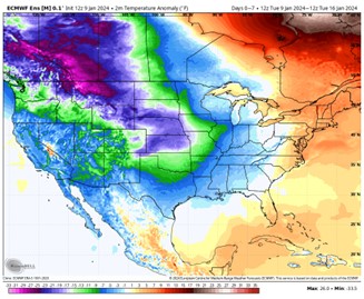
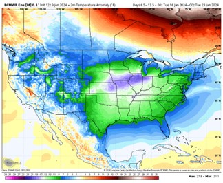
We had a stratospheric warming event in early December 2023; therefore, it is no surprise what we are seeing for the week ahead. The two images, courtesy of WeatherBell, show 7-day surface temperature anomalies some 20-25 degrees below average into the Rockies and Heartland ending on January 16th. Those anomalies shift south and east the following week, affecting the Midwest, South, Southeast, and eventually the East. This will yield over two weeks of drastically cold temperatures over the nation’s Heartland.
In addition, we’re in a very active El Niño pattern, therefore the combination of the two may bring wintry weather to areas not usually used to seeing it.
[i]https://www.ucar.edu/


 The Polar Vortex has had more airtime over the last several years, and the term is latched onto when temperatures plunge well below normal in the winter months. This cold intrusion is linked to stratospheric warming events, which we touched on briefly in
Connect With Us